The Struggles of Searching for Loyalist Records

The Struggles of Searching for Loyalist Records

Recently I’ve been looking into some Loyalist records from early Canada. Thanks to government-funded digitisation programmes such as Héritage and the work of Library and Archives Canada, many sets of records once only available in the British Library or on 1960s-era microfilm at select national libraries are now online and free to access.

The digitised, handwritten documents found in such collections as the Upper Canada Land Petitions and the Haldimand Papers (two sets I’ve used quite a bit) also serve as excellent reminders that just because a source has been put up online does not mean that it will be easy to search through, read, or use. Even databases with an integrated online search application can give difficult or incomplete results due to many different factors. First, searches are often limited to name and location: content or subject is left out. This is promising for family history and genealogy research, but what if I want to know about early settlers to a specific region or find examples of cultural interactions between different groups? I’d have to go through page by page. The search engine (and, in some ways, the presentation of the collection) has therefore been aimed at genealogists rather than historians.

screen-shot-2016-10-24-at-10-58-55

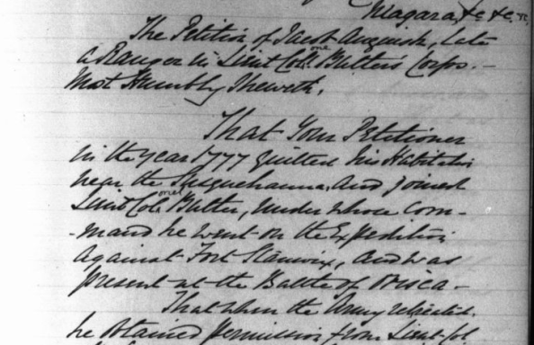
Excerpt from the Petition of Jacob Anguish to Lieut. Col. Peyster of Niagara, dated 4 August 1784. The Haldimand Papers, H-1448, 399 (pp. 419-21), Images 335-7.

The search results may also be affected by the quality of penmanship and the skill of the archivist. Continue reading

More Maps: Matthew Paris’ Great Britain

Earlier this summer I looked at using maps as primary sources for class as a way to generate discussion and highlight worldviews of the time periods and cultures in which the maps were created.  One of my favorite maps, and one that would be an excellent source in British History courses, is Matthew Paris’ Map of Great Britain, produced in 1250.  This map is now in the British Library.

britannienkarte_des_matthew_paris

Matthew Paris, Map of Britain (1250) – photo credit: wikimedia commons

Not only is the map visually appealing, particularly in its use of color, drawings of miniature battlements and city walls, and ability to seize the imagination, it is also the oldest surviving map to show such a high level of detail and accuracy.  Over 250 places are identified on the map, with Scotland clearly set apart by Hadrian’s Wall and the Antonine Wall.  I particularly enjoy the depiction of the Firths of Forth and Clyde sharply cutting through Scotland to almost meet.  Scotia and Wallia (with an elaborate Mount “Snaudun”) are identified by name, along with areas such as Devonia and Sufolck. The side bars identify the nearest land in each direction.  London, in the bottom center of the map, appears to have all roads leading to it (notice how the towns line up above it) along with a snake-like Thames.

We can see that the land depicted on the map is distorted, but even with this it was still extremely accurate for its time.  As the British Library site describes, Paris’ depiction was likely based on both travelers’ accounts and Ptolemy’s geography.

Matthew Paris was a monk at St. Alban’s Abbey in England, where he lived all of his adult life.  He was an historian, writer of chronicles, and artist.  Paris drew four maps of Britain, of which this is the most detailed.

Just think about the Hereford Mappa Mundi from my previous maps post.  As Simon Garfield emphasizes in On the Map, Matthew Paris created his map of Great Britain about fifty years before the mappa mundi was produced, making Paris truly stand out as a unique mapmaker of his time.

Resource Digitization: The Blogs

We all benefit from the efforts of libraries, archives, museum, and government bodies to organise, catalogue, and digitise documents and collections, but it can be very hard to keep up with what’s online! A collection you searched for which you were disappointed to find as only available on microform through inter-library loan only a few months ago might now be accessible from your living room. In this era of digitisation, what’s the best way to keep on top of what sources are coming online?

Following the blogs of libraries and archives that hold the types of material and specific collections you are typically interested in, especially those with government funding who are more likely to be able to devote people, money, and resources necessary to digitise and host online collections, is a great way to start.

For example, while I was conducting some genealogical research, I found evidence that a land petition of my 6x great-grandfather, a United Empire Loyalist, was in the Haldimand Papers. I prefer working with full-text primary sources rather than printed summaries or indexes, but the original papers were in the British Library and microfilm copies were available in Canada but nowhere near where I was living. I took note of how to find them and stored that away for another day. A few months later Library and Archives Canada blogged about their latest digitisation efforts and amazingly the Haldimand Papers was on the list! And that’s when I realised that these blogs can valuable tools for furthering one’s research.

It seems that most university libraries nowadays have one or more blogs, so why not Google your favourite library + blog and see what’s on offer. To get you started, here’s a list of some great blogs from libraries and archives that reflect upon the digitisation of resources and material of interest to historians of British and Irish global history. Feel free to let us know your favourites in the comments below!